“Terrain Analysis” – LiDAR Project
🌐
Public
Technology Title
LiDAR (Light Detection and Ranging)
LiDAR (Light Detection and Ranging)
Project Title
"Terrain Analysis" - LiDAR Project
"Terrain Analysis" - LiDAR Project
Category
Geoscience
Geoscience
Authors
shubham@mailinator.com
shubham@mailinator.com
Short Description
Utilize LiDAR technology to analyze the terrain of a large area, creating high-resolution 3D models and identifying geological features such as slopes, valleys, and ridges. The project aims to provide
Utilize LiDAR technology to analyze the terrain of a large area, creating high-resolution 3D models and identifying geological features such as slopes, valleys, and ridges. The project aims to provide
Long Description
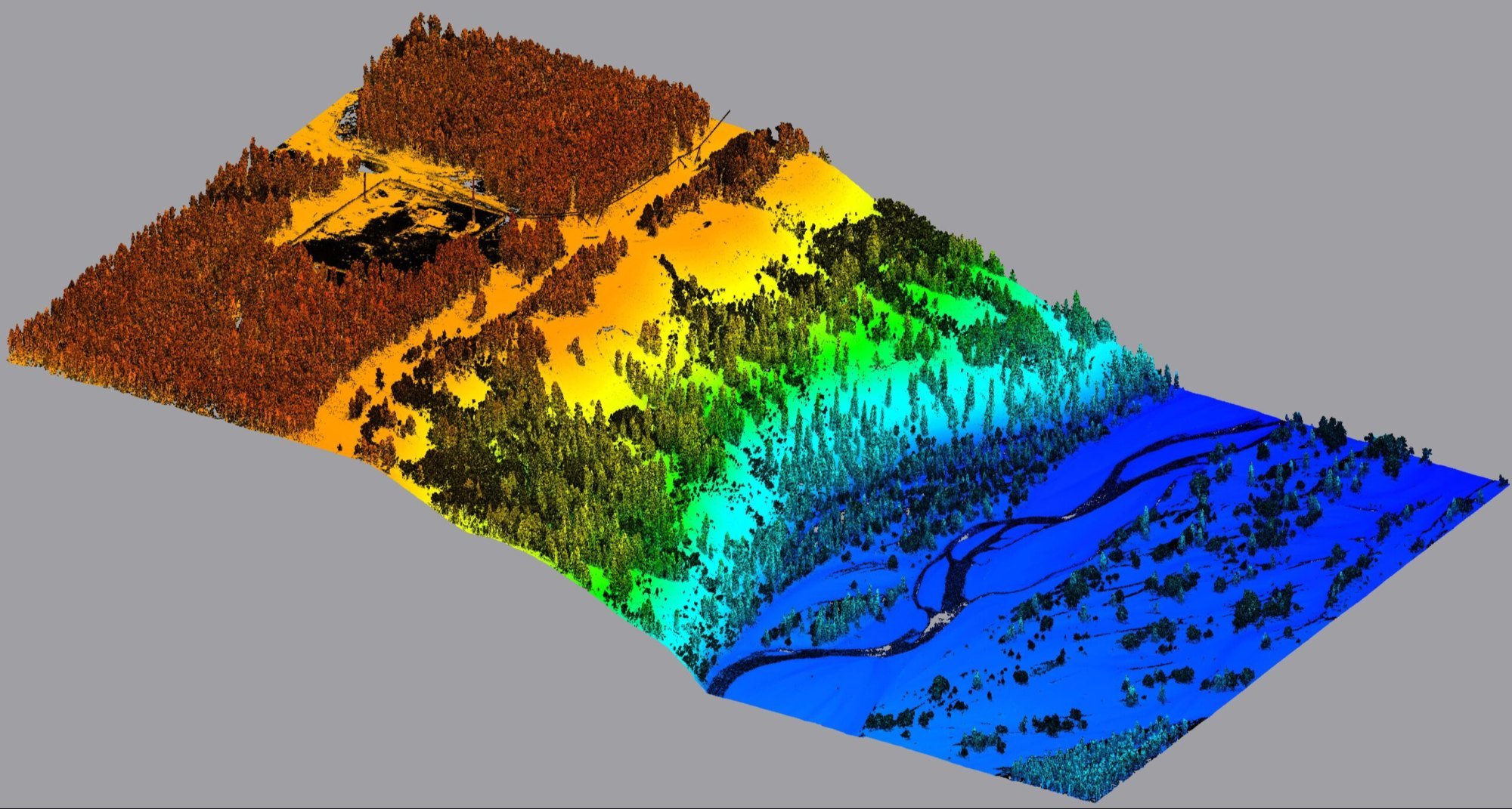
The project utilizes LiDAR (Light Detection and Ranging) technology to capture high-resolution topographic data of a large area. LiDAR systems emit laser pulses towards the Earth's surface, measuring the time-of-flight and wavelength of the reflected signals to calculate precise distance and elevation values. The collected point cloud data is then processed using specialized software to create detailed 3D models of the terrain. The 3D models generated through LiDAR technology enable the identification of various geological features such as slopes, valleys, and ridges. By analyzing the point cloud data and 3D models, researchers can extract valuable information about the terrain, including slope steepness, aspect, and curvature. This information can be used to classify the terrain into different geomorphological features, such as valleys, ridges, and plateaus.The high-resolution 3D models and extracted geological features can be used for a wide range of applications, including land use planning, environmental monitoring, and natural hazard risk assessment. For instance, the detailed topographic data can be used to identify areas prone to landslides or erosion, allowing for targeted mitigation and conservation efforts. Additionally, the 3D models can be used to analyze the impact of climate change on the terrain, such as changes in snow cover, glaciers, or vegetation patterns.The project aims to provide accurate and reliable data for informed decision-making and sustainable management of the environment. By leveraging LiDAR technology and advanced data processing techniques, the project delivers high-quality 3D models and geological feature data that can be used by researchers, policymakers, and stakeholders to support environmental conservation, land use planning, and natural resource management.
The project utilizes LiDAR (Light Detection and Ranging) technology to capture high-resolution topographic data of a large area. LiDAR systems emit laser pulses towards the Earth's surface, measuring the time-of-flight and wavelength of the reflected signals to calculate precise distance and elevation values. The collected point cloud data is then processed using specialized software to create detailed 3D models of the terrain. The 3D models generated through LiDAR technology enable the identification of various geological features such as slopes, valleys, and ridges. By analyzing the point cloud data and 3D models, researchers can extract valuable information about the terrain, including slope steepness, aspect, and curvature. This information can be used to classify the terrain into different geomorphological features, such as valleys, ridges, and plateaus.The high-resolution 3D models and extracted geological features can be used for a wide range of applications, including land use planning, environmental monitoring, and natural hazard risk assessment. For instance, the detailed topographic data can be used to identify areas prone to landslides or erosion, allowing for targeted mitigation and conservation efforts. Additionally, the 3D models can be used to analyze the impact of climate change on the terrain, such as changes in snow cover, glaciers, or vegetation patterns.The project aims to provide accurate and reliable data for informed decision-making and sustainable management of the environment. By leveraging LiDAR technology and advanced data processing techniques, the project delivers high-quality 3D models and geological feature data that can be used by researchers, policymakers, and stakeholders to support environmental conservation, land use planning, and natural resource management.
Potential Applications
Land surveying and mapping for urban planning and development, enabling accurate assessments of terrain difficulty and land use suitability.
Environmental monitoring and management, such as tracking changes in land cover, deforestation, and soil erosion.
Natural disaster prevention and response, including landslide and flood risk assessment, and damage assessment after an event.
Infrastructure planning and construction, such as designing roads, bridges, and buildings that are adapted to the terrain.
Archaeological research and cultural heritage preservation, allowing for the detailed documentation and analysis of sites.
Forestry management, enabling the accurate measurement of forest biomass and the planning of sustainable forestry practices.
Mining and resource extraction, facilitating the identification of resource deposits and the planning of extraction operations.
Climate change research, providing data on glacier and snowpack changes, and the impacts of climate change on terrain.
Emergency response and search and rescue operations, allowing for the rapid assessment of terrain difficulty and the planning of rescue routes.
Autonomous vehicle and drone navigation, enabling the creation of accurate and detailed maps of terrain for navigation systems.
Open Questions
1. How can the high-resolution 3D models generated through LiDAR technology be effectively integrated into land use planning and environmental monitoring applications to support sustainable development?
2. What are the most significant benefits and challenges of using LiDAR technology for natural hazard risk assessment, and how can it be used to identify areas prone to landslides or erosion?
3. How can the detailed topographic data provided by LiDAR technology be used to analyze the impact of climate change on terrain features such as snow cover, glaciers, or vegetation patterns?
4. In what ways can LiDAR technology be used to support archaeological research and cultural heritage preservation, and what are the potential benefits and limitations of this approach?
5. How can the 3D models and geological feature data generated through LiDAR technology be used to inform infrastructure planning and construction, such as designing roads, bridges, and buildings that are adapted to the terrain?
6. What are the potential applications and benefits of using LiDAR technology for forestry management, and how can it be used to accurately measure forest biomass and plan sustainable forestry practices?
7. How can LiDAR technology be used to support mining and resource extraction operations, and what are the potential benefits and challenges of this approach?
8. What are the potential benefits and challenges of using LiDAR technology for autonomous vehicle and drone navigation, and how can it be used to create accurate and detailed maps of terrain for navigation systems?
9. How can the point cloud data and 3D models generated through LiDAR technology be used to classify terrain into different geomorphological features, such as valleys, ridges, and plateaus?
10. What are the potential limitations and sources of error in LiDAR technology, and how can they be mitigated to ensure the accuracy and reliability of the data and results?
Image
Keywords
Third Choice
Third Choice
Email
shubham@mailinator.com
shubham@mailinator.com